
This research began in 2016 thanks to a virology paper on the spread of the Ebola epidemic in the city of Freetown. I am not an epidemiologist, but I have been dealing with informal settlements in West Africa for more than ten years and one of the main focus of my research has always been Freetown.
Some of those data were strange because they seemed to go against the common representation of slums as the main outbreak of the virus.
It took a long time to cross numbers, percentages, neighborhood boundaries, but above all a forced quarantine was needed to understand this story in depth. today, unfortunately, the terror of contagion and the sad list of victims are part of our daily lives and it is easier for us to understand the diffidence in meeting anyone, the fear of an invisible and threatening presence.
Above all, we can understand the need to search for a scapegoat, the reassuring anthropological need to feel that the enemy is not among us, comes from outside, from someone we can fight or marginalize.
This is the story of a city, Freetown and of many urban poors who at that time were doubly victims: of the disease that affected everyone and of the stigma that unjustly painted them as infecters.
It is a long story, but in these difficult times it had to be told, as a warning or just for a matter of justice.

The subject of this research has a name with a sweet and harmless sound, but that causes a thrill of fear.
Ebola.
It is one of the most lethal hemorrhagic fevers, it spreads through contact with bodily fluids of infected people and in about 50% of cases it quickly leads to death; a percentage that can even exceed 80%.
First isolated in the Democratic Republic of the Congo, it owes its name to a river in the region and strikes this country with dramatic repetitiveness, so much that the latest epidemic ended only a few days ago, in early March 2020.
However, the largest epidemic of Ebolavirus ever recorded erupted between 2014 and 2016 in West Africa, mainly in Guinea, Sierra Leone and Liberia: 28,000 confirmed cases and over 10,000 victims. But probably the deaths have been many more, especially in remote rural and forestry areas.
The study focuses on Sierra Leone, a small country of 7 million inhabitants in which 12,000 were infected and nearly 4,000 died in the period between February 2014 and November 2015, with few cases up to the beginning of 2016.
In fact, the World Health Organization declared over the epidemic only on March 17, 2016.
Over two years of forced coexistence with fear and death.
Ebola is in Town!
On 11 July 2014, Freetown feels safe: the cases of Ebola are about 300 but the epidemic is far away, among the forests of the north-east, at hundreds of kilometers.
The controversy in local media is still monopolized by those who deny the existence of the virus, by those who say it is a witchcraft and by those who believe that the epidemic was widespread by the imperialists to exterminate Africans.
That afternoon, a man is accompanied to the hospital with a fever and is subjected to the EVD (Ebola Virus Disease) test, the result is positive.
It is panic: Ebola is in the capital, the place where more than a quarter of the Sierra Leoneans live piled up.

The government, taken aback, starts taking measures and a national emergency is set up in August. The army is deployed to isolate the outbreak regions of the east and prevention and information programs are activated.
28,500 experts and volunteers are involved in a massive door-to-door awareness process. This also involves the reconstruction of all the contacts of the infected people and their forced quarantine for 21 days, the incubation time of the virus.
The country is practically a commissioner of the WHO, which is beginning to seriously fear the evolution in the pandemic. The construction of treatment centers begins in record time; in the capital region there are ten quarantine centers and five hospitals authorized to treat patients.
The peak of the cases occurs between September and November 2014, dozens of infected people are registered every day, the battle seems lost, but in January 2015 the curve of the infections begins to slowly decrease.
At the end of the nightmare, the Freetown Region has 4955 confirmed cases and almost 2000 victims.
Freetown, a city hungry for space
On 10 May 1787, with the support of some British philanthropists, a hundred liberated African slaves arrived on the coast of Sierra Leone. They chose to settle in an enchanting place: a plain overlooking the sea and dominated by high wooded mountains crossed by streams that descended into the ocean between red rocks and golden beaches.
A few years later the new city was baptized Freetown and began to house more and more slaves freed from ships intercepted on the route to America.

Proclaimed a colony and then the capital of British West Africa, the city grew incessantly throughout the 19th century, occupying almost all the flat areas. In the twentieth century and especially after the independence (1961) the place chosen by the first settlers proved to be unsuitable for enduring migration to the city.
Freetown stands in fact on a mountainous peninsula, squeezed between the steep hills and the sea. The development of the city in modern times has therefore been directed along the coasts, creating a linear settlement of over 30 km.
But space is still not enough. Expecially during the civil war, when the city is one of the few safe places in the country, all unoccupied areas were built, such as the banks of streams, beaches and cliffs. Informal settlements sprout everywhere, in the mouths of rivers and on the steep slopes of the hills, deforested and terraced.
Yet the hunger for space does not concern only the urban poor: in the last 20 years all the hills around the center have been systematically deforested and built with private villas, compromising the biodiversity of the area and above all the stability of the slopes.

And the city continues to grow, out of all proportion.
The chronically weak service networks are unable to respond to the growing demand for water and electricity, even the administrative division is struggling to chase this continuous expansion.
Freetown is in fact located in the region called “Western Area” divided into two departments: WA Urban and WA Rural which includes mountainous and rural areas but now also a large part of suburbs built in the last 20 years.
In 2014 the population of the region is around 1,500,000 people, of whom one million live in the urban area itself.
The slums of Freetown
The word slum is usually associated with the “periphery”. This way of thinking is due to the typical organization of western cities: there is a center where opportunities, wealth, power (but also art and history) are concentrated, in contrast with a popular, poor and sometimes degraded periphery.
The condition of many cities in sub-Saharan Africa, including Freetown, is different: here too, the place where the opportunities are concentrated is the center, but the daily challenge for survival requires staying as close as possible to it.
Each free space is therefore occupied, starting from the most central and attractive areas such as the cliffs or the banks of the rivers, a stone’s throw from the streets of the “City”. Freetown has a leopard spots urban pattern in which informal settlements sprout almost everywhere and become a fundamental part of the social and economic life of the city.
As a result, there are many slums in the city, an estimated eighty. Many are small settlements of few houses, others are larger areas where thousands of people live.
Unlike other African capitals, however, there are no megaslums: in 2014 the six main settlements had a population between 10 and 15,000 inhabitants; three are on the coast or at the mouth of streams (Congo river, Kroo bay and Susan bay) and three on the hills above the city (Dworzack, Mont Aureol and Moyiba). Then there are at least another ten slums with a population between 5 and 10,000 residents, including Cockle bay, Magazine Wharf, Moa Wharf and Colbot.

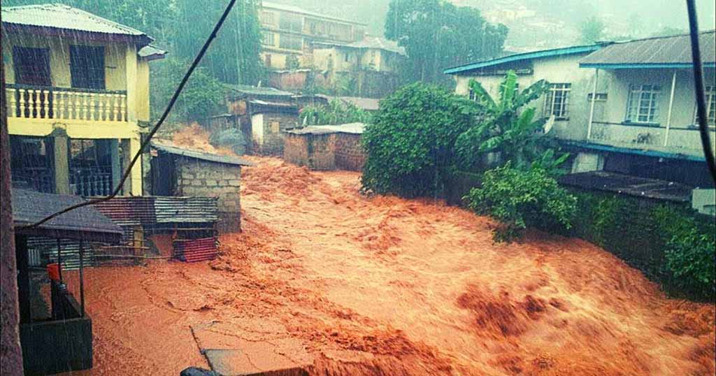
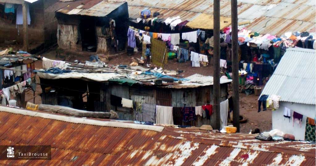
The coastal slums are the most impressive: crammed on the mouth of streams and on piles of compacted waste, they have a very high population density, combined with a severely compromised environmental and health situation.
Space is less and less and it must be created: wooden cages filled with waste gain ground from the sea and allow settlements to grow, increasingly precarious, increasingly in danger. Alleys a few tens of centimeters wide creep between the sheet metal shacks; people live in fear that the next flood or the next storm will take away everything.
The hilly slums, on the other hand, are created by terracing the steep slopes surrounding the city. Population density and pollution levels are much lower than the settlements on the coast but the houses are significantly larger. Here the main danger comes from the earth: deforested and impoverished soil often does not hold up and landslides suddenly swallow houses and people.

The widespread informality makes it very difficult to distinguish a slum from an “official” settlement; in addition to the density of the buildings the main dividing line must often be sought in the sense of belonging to a community, which is generally stronger among slum dwellers rather than ordinary citizens.
A sense of community that must be associated with the extraordinary importance that these settlements have in the urban economy: activities such as the transport of goods by water or by other non-motorized means, the recycling of waste or the retail trade have their main center in the slums and allow the relative well-being of a significant proportion of residents.
In fact, behind these settlements of rust and waste there is not only misery or resignation: the craft activities are feverish and extraordinarily lively and the social extraction of the residents is very varied.

The wards (administrative districts) that have a higher percentage of slum residents are no. 378 and 384; in these, between 50% and 70% of the total inhabitants live in a slum.
Also in ward 374, 377 and 382 the percentages of slum dwellers are significant (40% – 50% of total residents).
Write these numbers down because we will find them later.
Common perception of slums in Freetown
For at least twenty years, the city of Freetown has identified all its problems with slums. A common perception fueled by some politicians and opinion leaders and shared by the great majority of citizens.
It does not matter that a significant part of the formal or informal economy is guaranteed by the inhabitants of these neighborhoods and that the survival of the city itself is linked to their fate: every time a problem occurs, the slums are its natural scapegoat.
When a flood hits a coastal slum, for example, the invectives against the flood victims arise, considered guilty rather than victims of a situation mainly due to the absence of efficient infrastructure, planning and services.
An absurd stigma: as we have seen, Freetown is a complex city in which informality mixes with the official neighborhoods and the residents share the same problems and the same emergencies. In a 2012 report, UN-Habitat ranks Freetown among the cities with the least disparity in access to resources and services; a data that is not at all positive as it should be read downwards: Freetown is a fairly poor city.
As expected when Ebola arrives in town, the effect on this attitude is fuel on fire.
The reactions to the epidemic are still conflicting: someone is skeptical or confused by the absurd fake news that spread, others are panicked but everyone agrees to see slums like cancer to be eradicated before it is too late.
Congo River, a stream on whose banks is one of the largest slums in the city is renamed the “Ebola river”, just as the slums of Kroo bay and Susan bay are often renamed Ebola bay or Virus bay. Not a day goes by when politicians, newspapers, institutions and civil society do not throw themselves at slums demanding their removal or at least forced quarantine.
Foreign news reinforce this position: Liberia has isolated the huge West Point slum with the army, forcing tens of thousands of desperate people inside. Nobody realized that this solution would be impossible to implement for all the dozens of Freetown slums and the government is accused of inefficiency and incapacity.

In December 2014 Osho Williams, a well-known MP from the ruling party, is hospitalized with a high fever. The diagnosis is already written: the neighborhood that Williams represents is the one where the largest slums in the city are located (Kroo bay and Susan bay); for weeks the deputy committed himself to raising awareness among the communities, going around the slums and organizing meetings on meetings.
The government is in panic, the parliament risks closure and forced quarantine, and all because of the usual suspects: the slum dwellers, the infecters of the city.
A few days later Osho Williams is discharged because he results negative on EVD test but the stigma remains, even stronger than before.
An approach that involves also some international important media: National Geographic, for example, although not citing data (still not available at that time) writes in a reportage “in December Kroo bay was infested”.
A scientific article published on Lancet in October is titled “Ebola in urban slums: the elephant in the room”; a title certainly wrong: in Freetown everyone talks about that Elephant, that is the “problem” of the slums.
In the city the topic is so discussed and often with so aggressive tones, that it is surprising that there have been no cases of pogrom.
The stigma at the showdown – geography of contagion
What really happened in the two tragic years of the infection?
Let’s look at the numbers: the 2014 epidemic was also the first in which the data were organized systematically, mainly for containment reasons. It was essential for each infected person to rebuild the network of family members and contacts as soon as possible in order to isolate the maximum number of potential infected in quarantine.
Although the number of reported cases (and of the victims) is commonly considered underestimated, the VHF Database (Virus Hemorragic Fever) still allows to reconstruct the place of residence of almost all the approximately 5000 cases ascertained in capital, offering a realistic picture of the geography of contagion.
Scrolling through the database data, it is noted that in the Urban Area the wards with the most cases were no. 347 (Allen Town) with 213 infected and 78 victims and no. 352 (Congo Water) with 134 cases and 47 dead.
The surprising fact is that neither of these two districts includes a large slum.
At the regional level, the ward with most cases is the n.330, in the surroundings of Waterloo: 580 infected and 236 dead for less than 10,000 residents, in an area that looks much more like an agricultural village than a congested urban slum.

Let’s now observe the entire city by analyzing the incidence of the contagions with respect to the population of each ward.
There are 11 severely affected wards (with infected percentages ranging from 0.4 to 0.9%), but only two of them have a significant percentage of slum dwellers: no. 374 (Mabella – Magazine Wharf) with 40 – 50% of slum dwellers and no. 366 (Moyiba) with 30-40%. The other 9 wards have estimated percentages of slum residents of less than 20% of the population.
Even more surprising is to observe the data in the opposite direction: the wards with the highest number of slum residents (no. 377, 378, 382 and 384 reaching 60 – 70%) have infected population percentages of less than 0.2% with the only exception of the aforementioned no. 374 and no. 387 (Hill station) which reaches 0.3% – 0.4%.
In short, the worst areas of the infection do not overlap, except for small marginal parts, with the areas where urban informality is concentrated.

Rising above the commonplace
These data certainly contain inaccuracies and gaps, but the numbers are unequivocal and allows us to say that in Freetown slums were not the main outbreak of the Ebola epidemic. The commonplace that painted slum dwellers like the infecters ready to drag the whole city into the abyss does not hold up.
Do these surprising data mean that slums are optimal environments to defend against viral epidemics?
Obviously not.
It is therefore interesting to elaborate on the possible reasons that have limited the spread of the infection in places at high risk.
The main reason is most likely the presence of very strong informal and social networks. Invisible systems of relationships and hierarchies well rooted in many African cities and especially in slums.
The survival of these settlements, forgotten or even threatened by the authorities and institutions, is often made possible by a capillary network of relationships, internal hierarchies, family or neighborhood ties that allow the rapid transmission of information and the dissemination of common initiatives.
In situations of global “collapse”, when the institutions and all traditional references falter, the only lifeline is the implementation of informal and non-institutional relationship systems. Where these are already consolidated, the dangers of an emergency can be reduced.

It happened in the Moa Wharf slum for example, where Doctors Without Borders and WHO launched experimental awareness and monitoring programs that have proven extraordinarily effective. The same method allowed to stem a new outbreak in the Magazine Wharf slum (one of the hardest hit by the epidemic) at the end of 2015, limiting the infection to less than ten cases.
The small size of the slums of Freetown and the close relationships between its residents (in some cases still similar to those of rural villages), helped the monitoring of the infected people more than elsewhere. Here everyone knows everyone and the enhancement of this collective social control has contributed greatly to defeating the spread of the virus.
This is not a miracle: the great advantage that a slum can bring in the fight against an epidemic is precisely in the sense of community that very often is much more widespread than elsewhere.
Cities and Pandemics – Lessons from Freetown
What lessons can we draw from this story?
First of all, that stigma is always wrong and in some situations it can even become a crime, especially when it concerns social groups already in difficulty.
What happened in Liberia, where an “enlightened” president like Ellen Johnson Sirleaf in the excitement of the emergency came to deploy the army to isolate an entire informal settlement from the rest of the city, is a criminal act. Data from the epidemic say that Liberia has had a much smaller number of infections than in Sierra Leone but about a thousand more victims, there is no doubt that these policies of forced isolation in already difficult communities have contributed to raising the count of the dead.

It is natural that health authorities look with apprehension at slums, they are in fact the places where “the perfect storm” of conditions favorable to the outbreak of an epidemic occurs.
Yet this research confirms that it is not only the “physical” characteristics of the places that promote contagion but they are above all behaviors, social habits and scrupulous respect for the authorities indications.
As we have highlighted, some informal settlements from this point of view can surprisingly be more reactive, organized and active than other urban areas, making a difference. Therefore, be careful, administrators and urban planners: in planning urban development interventions it is essential to prevent these characteristics of social cohesion from being lost.
They are very precious and for the survival of many people they count far more than a healthy and rational environment.
Like so many things, the urban project will change radically after this pandemic, and can no longer ignore health and epidemiological considerations.
We make sure that this change is not limited to becoming the usual list of parameters and standards or, even worse, of solutions that facilitate forced quarantine and confinement. On the contrary we should engage in a deeper reasoning on the fundamental role of relationships and the enhancement of the sense of community.
Expecially in Europe, now that we are in a very similar situation.
Let’s train ourselves not to allow the spreading of stigmatizations and trivializations: the periods of crisis are the ones in which it is easier to see collective psychoses and the scapegoats hunts. Situations that we have already partially experienced (the Chinese, the illegal immigrants, the Italians) and which undermine social cohesion, highly increasing the risks, for everyone.
Let’s train ourselves in the conscious respect of the authorities indications without falling into authoritarianism or into the desire for a police state: the army in the streets, the total curfew and the cancellation of any freedom may appear effective and reassuring measures but in the past they have often had opposite effects, fueling riots , mass leaks and the consequent increase in infection.
Rather, let’s train ourselves to enhance in all ways the active and responsible belonging to a community, both in our daily life (that as never before has been deprived of the aspects of socialization), and by building new forms of participation and sharing, also of the urban and public spaces.
Because a truly inclusive city is not only an ethical obligation, but an advantage for us all.
Federico Monica
Architect and Urban Planner, Ph.D. in Urban and regional planning. Founder of Taxibrousse studio, specialized in informal settlements assessment, slum upgrading strategies, low-cost and low-tech building processes.
Share this page!
Featured posts


TaxiBrousse is a design and consultancy studio for international development, we works in the fields of engineering, architecture, urban planning and environmental protection.
Follow us